Day 15 – Summer’s back!
Well, who’d have thought it? Met Eireann, the Irish weather service issued an apology for the weather forecast for yesterday. They said there’d be occasional showers in the east of the country (where the Rossnaree excavation is located) but instead there was virtually continuous grey wet drizzle for much of the day. You have to take the rough with the smooth – normally when the forecast suggests that there might be showers or rain, I have found that we have a good chance of being lucky. The rain takes a little bit longer to get across the country to us in Rossnaree and we usually seem to escape the worst of it. To have the opposite happen once is, I think, acceptable because of the number of escapes we have had over the last few weeks.
.
.
.
.
.
.
.
The weather on-site was perfect – bright spells and cloud, not too hot, and no rain of any sort. Everyone was in a good mood (I think) and there was an air of quiet industry over the site for much of the day. Ciara was working single-handedly in Cutting 7 for the morning giving one last clean-back to the exposed surface there to make sure that no possible features had been missed. After lunch, Matt did a plan of the grave again, detailing the position of each of the bones and we spent the afternoon excavating, lifting and carefully packaging each bone. Each piece was numbered on the plan and photographed and wrapped and labelled for storage and later study.
Mags and Sophie continued to take down the last of the disturbed layer of soil overlying natural in Cutting 8. Despite the rain the previous day, the soil was drying out very quickly making the identification of the different colours difficult. The layer closest to natural has quite a mottled appearance – it is a mix between the compact yellowish natural and ploughsoil and has frequent worm holes through it. There are still occasional flecks of charcoal and occasional fragments of bone so we are certain that the surface is definitely not natural. Hopefully we will be finished in this cutting very soon.
.
.
.
.
.
.
.
.
.
.
.
In Cutting 6 Eimear continued to dig the section at the southern end of the cutting and a number of interesting finds came up. Below the upper layer of charcoal rich soil there is a thick deposit of almost pure ash and within this there is a deposit of animal bone, probably cow, including a mandible (jaw) and rib, among others. These seem to have been deliberately deposited with a number of burnt stones (one of which Eimear named ‘the raspberry stone’ because of it’s vivid colour!) and also an intact bone needle/pin. This is definitely find of the week and although it can’t be closely dated, it definitely belongs to the early medieval period. The Neolithic remains elusive.
We set Darren up at the northern end of the cutting doing a similar section to Eimear across the ditch. We seem to have clear edges to the ditch feature with natural visible on both sides. Again, the fill is very rich in charcoal and ash and the edge of the cut of the ditch is quite steep. There was still no sign of the base of the ditch cut in the evening when we were finishing up. Flint artefacts were frequent but it is not clear whether they are indicating a date for the digging of the ditch or whether they were disturbed and incorporated into the fill of the ditch during the early medieval period. Lots to look forward to on Monday.
Day 5: One week done, three to go…
First thing each morning I check over the site to see that it is as we left it the evening before. This morning, there was evidence of a visitor for the first time since we started and it looked like they were having a go themselves. They may have been small and furry and luckily they confined themselves to one of the spoil heaps and didn’t make a mess!
.
.
.
.
.
.
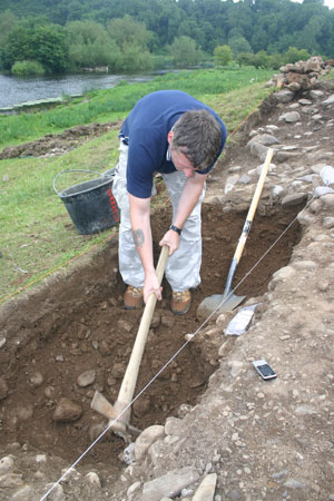
The work of the previous days continued, unfortunately at this stage it is fairly repetitive – mattocking, shovelling and sieving – and not very exciting, apart from the occasional finds of flint. Once we get all of the ploughsoil off and we can see archaeological features, things will be much more exciting. Nonetheless, everyone has their trowel at the ready, just in case.
Continuing what I said in yesterday’s post about mattocks and shovels being the more used tools on archaeological sites, trowels are nonetheless regarded by the public as the quintessential archaeological tool. This is also true for archaeologists themselves and trowels become very important personal possessions over time and even indicators of the extent of the experience of the owner. The loss of a seasoned trowel often triggers a grieving process on the part of the owner, especially if the trowel has been with its owner for a long time. All of the volunteers on the site at Rossnaree bought their own trowels for the dig and will hopefully be using them again and again in the years to come. With use, trowels can become very worn with the ‘blade’ wearing down to a fraction of its original size. The more worn a trowel is, the longer the owner has been digging and the more experience they have.
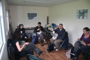
Conditions on the site were unpleasant today with persistent misty grey drizzle occasionally developing into light rain for much of the morning. Sieving the soil became quite difficult, especially soil taken from close to the ground surface. Soil from deeper down was still relatively dry and sieved very well. Everyone got a bit muddy over the course of the day. Above is a selection of the wellies and wetgear in use on the site. Breaktimes become all the more important in these conditions and today, for the first time, we had tables and chairs in the cabin. Thanks again to Fin for the early delivery on the way to the Blackfriary site in Trim.
Again, in spite of the conditions, very good progress was made and we are aiming to have both cuttings cleared and ready to be cleaned back (with trowels!) early next week. A big thank you to all of the volunteers who worked so hard all this week. I hope the weather hasn’t put you off and that you’ll all be back again on Monday for a more interesting and exciting week. In sporting parlance, it is still all to play for!
Day 18: The devil is in the detail
Today, a very dramatic occurrence took place – Trench 4 disappeared. Seriously, we had completed all the necessary work in that trench and yesterday, Kieran had started to backfill. Today, this job was completed in fine style by Kieran, Eimear, Niamh and Darren. We were even able to replace the sods back on the top. In a few weeks, it will be like we weren’t there at all. It is a bit sore having to fill in after so much slow painstaking work, but that is the name of the game in research archaeology.
.
.
.
.
.
Some very serious work was done in Trench 1 today by a very dedicated group of individuals. The first job was done by Louise who had yesterday discovered the pit-like feature at the south side of the trench. She drew a quick section of the feature and a plan as well. Once this was done, it was possible to start excavating again and although it had been decided not to excavate the full extent of the trench in order to save time, they went ahead and took out the remaining layers anyway. A fantastic piece of work. At this stage the final jobs to be done here are to draw the sections and take the samples. By the afternoon, Kim and Louise were setting up to start this so by tomorrow lunch time we should be ready to take samples. Things are moving very quickly!
Meanwhile in Trench 1 Matt and Darren started off the morning cleaning up the lower portions of the feature they had uncovered yesterday. They were preparing for record photographs and also for planning and drawing the section. The feature itself is interesting because it seems to be at a lower level than the wall and thus is earlier in date. It seems to have functioned as a revetting feature which held the slope in place. The slope is composed of quite loose gravels and this may have caused problems for the inhabitants of the site who wanted a more stable slope. As I mentioned yesterday, there seem to be similar features peeping out from the grass in the slope further along from the trenches where we are digging. This cleaning was completed by mid-morning, after which Darren went to Trench 4 and Matt got going setting up for drawing the plan. While they were cleaning down onto this final level, a number of very interesting finds came up which throw a lot of light on the date of the activity in this area. Almost directly where the wall feature made of large cobbles had stood within the bank, they found a portion of a double-sided comb, possibly made of antler. This is little bigger than my thumbnail but is nonetheless very significant. Finds like these typically date to the eighth century AD or later (as far as I know – I’ll have to check this) and it tells us that the bank/wall (and probably the ditch beside it as well) must date to this time or a little bit later. This is clear dating evidence for the feature from excavation and means we don’t have to wait months for radiocarbon dating in order to find out what date this activity was.
A couple of other finds from this general period came up within hours – a small copper-alloy strap and a fragment of an iron vessel. Sometimes this is the way things work out in archaeology – you don’t get the crucial finds until almost the last minute. in spite of so much flint from these layers, it is now clear that the feature is Early Medieval. The flint was probably on site already and was incorporated into refuse material used by the Early Medieval occupants of the site and there is still no doubt that the site was intensively used in Neolithic times. We now also know that it was also used intensively in Early Medieval times as well. We have another multi-period site, a bit like how the site at Knowth across the river was used. The big questions now are are the other banks and ditches the same date and where are the structures that were used in prehistoric times.
Day 14: No drama today, just another day’s work
No thunder or lightning today, just one or two light showers of rain. No sun either and the day was a bit cooler than previous but nonetheless was quite pleasant.
Now with the weather report out of the way we can move on to the work done on site today. In Trench 4 (I always seem to start with this one, possibly because it is the nearest one to the site) Kieran drew a plan of the cutting showing the extent of the ditch, the slopes to the base on each side and the rest of the cutting. This view complements the section he drew yesterday – the section shows the side-view or elevation of all of the layers in the side of the trench while the plan view gives the bird’s-eye-view of the feature excavated. At the same time, I took a series of soil samples from the sides of the trench for magnetic susceptibility analysis. Samples had been taken previously at a higher level and readings have also been taken across the surface of the trench before the trench was desodded so we will end up with a very good record of how magnetic susceptibility varies with depth within the ditch. To remind readers, magnetic susceptibility measures the ability of the soil to become magnetised when a magnetic field is introduced and is a very good indicator of past burning or disposal of organic material like food waste or manure.
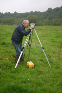
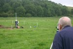
Both of these are of course closely related to settlement. The soil samples will have to be processed at a later stage after the excavation is over before the analysis takes place. They will be dried, sieved to remove stones and weighed to produce equal sized samples. In this way, we will be able to get accurate and directly comparable values for magnetic suceptibility. At the end of Kieran’s planning process, the final job to be carried out is to take levels of the area to give an impression of how undulating the planned surface is and to give a feeling for the relative depths of features. This is done on site with a simple dumpy level, which is being used in the photo by Chris who was visiting the site this morning. Chris was one of the geophysics team who first discovered and mapped the enclosure back in 2008 and he was anxious to see for himself how progress was going. In the photo, Kieran is holding the staff, which is like a giant ruler. He places this on each spot in the trench that he wants measured and Chris takes the reading through the level, which is like a small telescope that has been set up on the level. We know the height of the level in space (this has been established already) so we can calculate the heights of each point measured and recorded by Kieran on the plan.
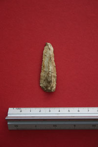
In Trench 1 the work of the past number of days went on and Darren and Matt removed more of the dark, rich organic layer overlying the cobblestones making up the core of the bank. Lots more animal bone was found, some of which seems to have been burned (this will hopefully be confirmed by our animal bone specialist who is visiting next week). Some nice pieces of flint were also found including various flake fragments, a scraper fragment and a complete blade.
Beneath this layer the cobble stones were coming up very nicely and the site in this area at least was beginning to feel more than a little like an early medieval cashel. Because these date to between 500 and 1000AD, I wasn’t too happy with this idea! I still believe the site is Neolithic (4,000 to 2,500BC). I believe the staff have a book open on the date; one bet is that it is 850AD. Traitors! Seriously, no artefacts have been found that suggest that this site is anything other than prehistoric (and probably Neolithic) although, as I said before, some pottery would be very nice and would help remove any doubt. The cobbles in the wall do seem to have collapsed a bit over time; they are most intact at the bank end and less distinct moving eastwards away from the bank. There is also a lot of soil in between them which probably filtered down from above over the years too.
In Trench 1 more progress was made removing one of the ditch fills. Gary and Niamh cleaned up and exposed the layer of stones within this layer and, although at first glance they seem to have a pattern to them and appear to be part of a structure, this is completely coincidental. The excavators are certain that this just happens to be the way the stones settled after rolling or sliding down the slope from above, finally settling at the lowest part of the ditch. We will clean them a bit more and record them in plan anyway, just to be sure.
Day 13: Thunder and a skull
The day started out well in line with the Met Éireann predictions. However, the forecast was for deteriorating conditions with frequent heavy showers in the afternoon. It was looking like we were going to lose some time. However, it only rained once at lunch time but it was a very heavy and prolonged shower. Once it finished, despite being surrounded by slaty grey thundery clouds, it stayed dry.
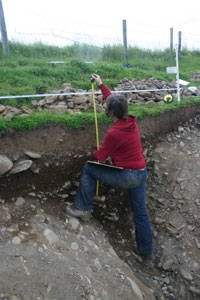
In Trench 4 Kieran got stuck into recording the section. The process is to set up a baseline making sure that it is level. In the photo this is just below the edge of the trench and there is also a long measuring tape attached to it to help with the drawing. This is used to measure down to points to be recorded, e.g. the tops of layers, stones, the edges of a ditch. Each point is meticulously measured and plotted on a scale drawing so that there is a permanent accurate record of the material that has been dug through on an archaeological excavation. It is like a giant version of join-the-dots. Kieran was recording the various fills of the outer enclosure ditched as revealed in the side of Trench 4. Even with all of the modern technology that is available now, there is still nothing to beat the trained and experienced eye of an archaeologist, especially the person who has dug the particular trench. Some of the differences between layers are so slight and subtle that they are beyond the ability of machines to detect and must be drawn by hand. Even with all of the advances in digital photography it is still best to do this job the tried and tested way, even if it does seem slow.
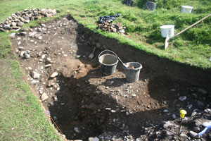
In Trench 1 Niamh and Gary continued to take down ditch fill material, sampling as they go. A layer of stones has appeared and the base of one of the layers that hasn’t shown previously do the plan is to expose the stones to see if they form any pattern or whether they join with any of the other stony layers exposed in the section. Although they are likely to be material that has gradually slipped down the slope from higher up coming to rest in the upper fills of the enclosure ditch, tomorrow should reveal full their extent and allow us to decide properly why the stones are likely to be there. In the photo it is possible to see the clear difference in colour between the face of the bank and the ditch cut, both of which are stony and more grey in colour, and the fill material which is much more brown.
Very good progress was made in Trench 1 today because of the extra personnel there. Deirdre and Eimear took over sieving duties for Matt and Darren so that the digging cound take place continuously. Good finds were still being found through sieveing including the usual animal bone and flint. The animal bone assemblage is increasing in size and although we are only recovering fragments in most cases, we hope that analysis of the bone will be able to tell us about the economy of the site, i.e., what they were raising and eating.
The picture of what is happening in Trench 1 is changing rapidly as a result. It now seems that the point where the ditch met the bank was defined by large cobbles which were mentioned already. These cobbles seem to have served as a revetment or low wall keeping the core of the bank in place and they also seem to mark the edge of a layer of cobbles within the wall. These will be further revealed over the next day or two and hopefully it will become clearer to us as to what they were for.
Towards the end of the day, however, another interesting find was made. A theme has been developing over the last few weeks that we’ve been finding cattle bones in significant places in the excavation today’s find was yet another example of this trend. Set on top of (or possibly within) the cobbles on the bank in Trench 1, what appears to be a cow’s skull began to be revealed. This may just be rubbish thrown out from higher up in the site but at the moment it appears to have been perhaps deliberately placed within the material in the bank of the inner enclosure. Is there a real theme developing in this site? Are cattle somehow important to what the site was used for? Hopefully we’ll have some answers before long.
Day 9: Soft day, thank God
We Irish have a ludicrous saying suggesting that we actually like the auld bit o’ rain now and then. Today might have qualified for the ‘soft day’ categorisation but there’s no way any of us on site were particularly pleased with it today. There were numerous heavy showers but the weather couldn’t make up its mind as to whether it was coming or going. The result was a lot of wettings and some very stop-start work. Anyway, the one good thing about the weather today was that some of our crew were not able to make it to site today because of other commitments. So not everybody had to be subjected to a soaking!
The work that we did manage to get done was limited but it nonetheless pushes us a little further towards our ultimate goal. In Trench 4, Kieran, Eamonn and Deirdre continued to peel the cultivation sol off the top of the fill of the enclosure ditch. Very few finds were coming out of the material being removed but Deirdre’s sharp eyes picked out a fragment of a rock crystal flake (sorry no photo). This is very small-less than half the size of your little fingernail-but is distinctive and unusual. Although more difficult to work into tools than flint (and harder for us archaeologists to recognise) it is clear that materials other than flint were often used by people in the Neolithic. In some cases it seems simply that where there was a shortage of good quality flint, people used other materials like chert and quartz as ‘second best’ alternatives. However, it is also possible that the materials chosen for toolmaking reflected the intended functions of the tools or reflected the identities of the people making the tools. We all have the good crockery at home for when visitors call. Similarly, craftspeople today often use unusual or distinctive materials as a sort of trademark. Perhaps this was going on in the Neolithic as well. The flake fragment we found is distinctive because it is a type of quartz which is almost transparent, like glass. This quality would not have been lost on the Neolithic people.
In Trench 1 we continued to take out the fill of the gully and we also drew the north-facing section exposed when we excavated the enclosure ditch. We also plotted the locations of the magnetic susceptibility soil samples we took yesterday. We managed to complete these various jobs by lunchtime between showers and then we transferred over to Trench 3 where there is also a bank and ditch feature. The plan was to start to take down the material filling the ditch in the same was as in Trench 1. We unfortunately didn’t get much done because of the rain but we did notice a larger number of bone fragments compared to Trench 1, reflecting the position of Trench 1 closer to the ‘core’ of the site.
Can’t decide whether the weather forecast was accurate; I think it was today. A blustery day is forecast tomorrow with scattered passing showers. I think we may be able to cope with that.
Day 7: ‘Now you’re sucking diesel’
The weatherman had warned of rain spreading into Munster and south Leinster by midday spreading to all areas over the afternoon so we were apprehensive about when this weather would actually arrive. The day was not as bright and as sunny but was still dry. The big news for the day was that we were joined by reinforcements in the form of Deirdre, a veteran of many previous excavations including Graeme Warren’s dig at Belderrig and Geraldine and Matt Stout’s dig at Site M, Knowth. A valuable addition to our small team.
Work focused on two areas today: Deirdre and Eamonn under Kieran’s supervision began to work down through the topsoil/cultivation soil in Trench 4, the site of the geophysical survey work on Saturday. Ultimately, the excavation of this trench will be a test of the accuracy of the various techniques we used during that survey.
The other area of activity was in Trench 1, continuing the explorations started yesterday tracing the extent of the ditch of the outer enclosure. Work went very well and by lunchtime, Matt had found the bottom of the ditch and by the end of the day he had found the sides of it as well, at least on one side.
The ditch turned out to be around 90cm deep, pretty much the depth indicated in the ERT section carried out over this area some time before. This is a very good result for us excavating the site, but also for Kevin, who has hard evidence to show how well the equipment works.
As if that wasn’t enough, out of the very base of the ditch, at 4.40pm, almost when the day was done and it was time to pack up to go home, Matt made another discovery. At the very base of the ditch, he uncovered an intact cow’s mandible. You may wonder why you should be excited about this. Granted, it is not the most exciting find and you’re highly unlikely to find one of these in any museum display. The main value of this find is that it can be scientifically dated using radiocarbon dating and an independent scientific date for the site can be established. It was in the perfect location for establishing an accurate date; right at the bottom of the ditch. This means that the bone must have made its way into the ditch very soon after the ditch was dug, presumably while the site was in use. If the bone was further up in the fill of the ditch, it could have made its way into the ditch some time later and thus would not be a reliable indicator of the earliest use of the site.
Furthermore, it seems that the bone may have been deliberately placed at the base of the ditch because it was found in a small ‘slot’ feature right at the base. This would further connect the bone to the initial digging of the ditch and the earliest use of the site.
It seems inevitable that there will be some rain over the next couple of days. Hopefully not too much!
Day 3: Establishing a routine
The weather is holding up well despite the predictions. Today we finished clearing off in Trench 3, which is close to the core of the site, and moved over to Trench 1, which has been set out over the outermost bank and ditch, to continue the process of cleaning down. In the same way as before, all of the topsoil from beneath the sod is sieved in order to make sure we get as many of the finds as possible. It seems that there was less activity at this end of the site as there are generally fewer flint pieces and much less animal bone than in Trench 3. Clearly, different activities were being carried out in different parts of the site. Possible domestic/residential activities were taking place close to the high ground in the centre of the site within the inner enclosures while there seems to have been different kinds of activity elsewhere. Hopefully as we dig further we will get a better sense of what some of these activities were.
The surface of Trench 3 was photographed, depths were taken and Kieran and Ailbhe got a start on planning the surface with a 1m square planning frame. This is a tricky process in this trench because of the steepness of the slope: it is not possible to lay the planning frame directly onto the ground surface and the corners have to be propped up to keep it level. The draughtsperson has to take care to look through the frame from directly above in order to accurately record the ground surface. It is a slow laborious process but it is still far better than a photograph because of the amount of detail it captures. Once Trench 1 has been fully cleaned down, it will also be photographed and planned in the same way.
We set out another trench, Trench 2, using a total station and we will move into it depending progress in the others. Once this was done, a magnetic susceptibility survey was carried out across the surface using a field instrument (see the Day 2 post for an explanation) and soil samples will be taken as the trench is dug. Using the field loop, care has to be taken to ensure that the loop is as fully in contact with the ground surface as possibly, otherwise an incorrect reading will result.
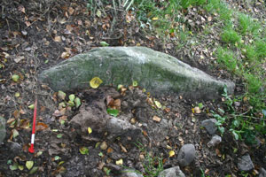
Other work carriedout on site today included setting out the final cutting, Trench 5. This is positioned around a greywacke slab lying half buried in the surface of the pasture field close to the hedge and the plan is to excavate it and lift it. The significance of this stone is this is the stone type that was used for the structural stones in the passage tombs built on the north side of the river. Recent geological work on the structural stones of Newgrange and Knowth has demonstrated that the greywacke slabs used are likely to have been transported to Brú na Bóinne from the coast at Clogher Head, Co. Louth, a distance of c. 20km. This stone is very significant because it is on the south side of the river and it suggests that there may have been a link between those who occupied and used the Rossnaree Enclosure and the builders of the passage tombs. Were both in existence at the same time? There is also a possibility that there may be art carved on the stone, although none is visible at the moment. Although it is possible that this was part of a passage tomb, there are no other indications that one existed at Rossnaree. It may originally have been a standing stone like similar examples in the land below Newgrange and also at the mouth of the Boyne at Baltray.
A bit of essential kit for the dig.
Spent the morning assembling a sieve for use on the excavation which starts on Monday. It is a sieve with a 5mm mesh, essential for recovering the smaller pieces of flint from the ploughsoil and other contexts.
The design is ingenious and is based on a ‘rocker’ mechanism. The sieve mesh is mounted in a frame where the long sides have gently curving lower edges (a bit like a sleigh). This unit sits into a table-like frame on legs. The sieve can then be easily rocked from one or both ends, taking some of the effort out of the process. I look forward to testing it out, it should help to boost our finds tally.
I think a similar design was used on the Bective Excavations Project last year – so they have no unfair advantage! Thanks to Liam for developing the sieve from ‘concept’ stage to a working reality!
We will also be using another sieve (we will be opening more than one trench) which will be based on a more conventional ‘suspended’ design. Big thanks to Emmet for designing, constructing and delivering that one. It will be interesting to compare performance of the two.
A little bit of friendly rivalry…
I have been told that there may be an element of competition between two of the IAFS projects: the Rossnaree Archaeological Project and the Bective Excavations Project. Both digs are scheduled to start on Monday 5th July for four weeks each. A book has been opened on the number of trenches, the square meterage opened, the number of finds recovered, the best find recovered…
The Rossnaree Project is starting at a distinct disadvantage as the Bective Excavations Project has already been running for a full season already. However, we’ll see what happens!
The low-tech ‘art’ of fieldwalking (surface-collection survey)
The structural elements of prehistoric houses and shelters were chiefly constructed of organic materials, very little of which survive for any length of time under normal conditions. However, we are fortunate that stone tools were used from earliest times through to the Bronze Age at least. These tools are usually of flint and a number of other rock types were also used.
In a ploughzone artefact scatter, finds that might normally be excavated from features on archaeological excavation sites have literally been ‘ploughed in’ to the ploughsoil with each tillage event. The surfaces and features with which they would have been associated are now largely destroyed and only the deepest elements of trenches, pits and post-holes survive below the ploughzone. The durable finds from the disturbed portion remain suspended within the ploughsoil and a proportion of these and later material are turned to the surface when fields are ploughed.
So, paradoxically, one of the processes that has contributed to the destruction of these site types actually allows us to ‘see’ beneath the soil without excavating. In effect, the plough does the excavating for us. The stone tools will, of course, be disturbed from their original contexts but generally speaking, scatters of material within the ploughzone will largely retain their spatial integrity and will be recogniseable if a suitable systematic method of recovery is used.
Research has demonstrated quite clearly that dense lithics scatters do not necessarily equate with settlement locations. In many cases, large scale working of materials took place at a remove from the settlement purely for safety reasons; freshly struck flint flakes and waste is as sharp as glass; not a material to have lying around the house in large quantities! There is a sequence which lithic raw material goes through from its initial quarrying and collection through to the finishing, use, resharpening, repair and eventual discard of tools. House sites are generally characterised by material that falls into the later stages of this sequence and there are generally larger proportions of tools, utilised flakes and blades, trimming (retouch) flakes (which often require sieving to recover on excavations) and prepared platform cores than would otherwise be expected.
The most common method is to walk available (i.e., ploughed/tilled) fields using a grid system with regularly spaced transects crossing over the field, resulting in the sampling of the surface of the field. The spacing of the transects is determined by the objectives of the survey. If it is a priority to locate small ephemeral sites (like Mesolithic work areas) or establish the internal structure of larger scatters, then a relatively narrow spacing will be required. If, on the other hand, a rapid assessment of presence or absence of artefacts relating to a series of different periods along with a rough indication of their locations is required, perhaps as a preliminary phase in a multi-stage landscape project, then a wider transect spacing will be adequate. Each transect is subdivided into regular stints of a set length so each find will come from a recordable location, which facilitates the plotting of finds on distribution maps. For the purposes of the current research, walkers were spaced 10m apart and stint length was set at 25m. Each walker can effectively cover a corridor of c. 2m wide, i.e. 1m to either side of their path, resulting in 20% coverage of the surface of each field.
The procedure adopted here for laying out the grid was to first choose the longest, straightest field boundary to act as a baseline and then, using a sighting compass, to set out the transects and stints at right angles to this. Transects and stints are marked with high visibility flags. Each transect was assigned a letter in sequence and within each one, each stint was assigned a number. Thus each stint will have a unique reference and finds are bagged according to what stint they come from. The transect letter and stint number are the equivalent of a context number on a conventional excavation.
The results of the field survey, once plotted, can be easily replicated or tested under differing conditions. Careful use of the same field grid from field to field is, of course, essential for results to be comparable. Dull even light is the best for fieldwalking as there are no dark shadows created on the field surface. Dry weather is, of course the preferred option for surveying; not only is it more comfortable but when the field surface is wet, colours tend to change to a uniform dark brown. In well weathered fields, however, damp rather than wet conditions can serve to highlight the distinct colours and smooth surfaces of flint. The number of walkers surveying on the day is also recorded along with the transects that they walked. This is essential as different individuals tend to see different things on the surface depending on their levels of experience. A subjective measure of each person’s experience can be made in order to weight areas that appear to be of lighter relative finds densities if it is felt that finds were being missed.
It is also important that fields be left for as long as possible before walking in order to maximise the effects of weathering. Frost helps to break up larger clods while rain and wind help to clean stones on the surface. Directly after the ploughing of a field very few artefacts will be visible. As with much other archaeological work, patience is rewarded and six to eight weeks of weathering will result in dramatic differences in surface artefact visibility. In the present survey, fields were usually walked some time after the crop has been sown, as a flat field surface is much easier to walk across than one that has only been ploughed. However, there is constantly a trade-off between the quality of the surface and the length of the crop. If a crop is left for too long it will damaged by walking on it, but generally speaking by this stage the crop is so high that it will begin to interfere with visibility anyway.
The finds are washed, catalogued and plotted on field maps. Identification of scatters can take place once this has been done. The assumption underlying this work is that the presence of a lithic scatter on the surface of a field is indicative of prehistoric settlement or work-related activity, not necessarily on that exact spot, but very close by. The presence of diagnostic artefacts can give broad indications of the dating of particular scatters while an analysis of the composition of ploughzone assemblages can identify the behaviours that were involved in their initial production. As has been mentioned already, lithic artefacts can belong to one of a series of stages in a sequence from initial collection through to eventual discard. Based on these observations, it has been established that a range of different activities can be recognised. Certain locations within the landscape may have been favoured above others for certain tasks.
Although this technique is not necessarily as exciting or attractive as some more high-tech approaches like aerial photography, geophysics or excavation, it remains an excellent way to analyse the uses of a prehistoric landscape on a large scale basis and in an extremely cost-effective way. Results of such a survey can then be used to target more costly high resolution techniques on areas that have potential in the form of artefact scatters. This approach is extremely successful and has led to the discovery of the Rossnaree Enclosure.
Artefacts from the Brú na Bóinne Fieldwalking Project
Below is a small selection of the artefacts found during the Brú na Bóinne Fieldwalking Project. In places where there has been prehistoric activity, the stone tools used by our ancestors often survive in the soil. Each year when a field is ploughed, some of these artefacts are turned to the surface and can be collected by archaeologists using appropriate survey techniques and permissions (from the National Museum of Ireland and landowners). Scatters of such material often indicate where intense activity, residential, agricultural, industrial, took place in the past.
The location of the Rossnaree Enclosure was initially identified as a scatter of flint and stone tools on the surface of a ploughed field. Follow-up survey using various types of geophysical equipment allowed us to look below the level of the ploughsoil and explore the extent, layout and some of the internal detail of this unusual site.


